
One Earth
Geospatial platform for global conservation and climate action
- Strategy
- UX
- Design
- Development
One Earth is a nonprofit working to accelerate climate solutions through nature conservation, regenerative agriculture, and clean energy transitions. To support this mission, Ronik designed and built an interactive, 3D data platform that brings awareness to their global conservation network.
Visit siteIn their most ambitious digital initiative to date, One Earth set out to create a dynamic, data-rich platform that would engage funders, scientists, and advocates in supporting conservation efforts worldwide. The vision was to present complex geospatial project data through the lens of bioregions—ecologically defined zones that transcend political borders and offer a more accurate framework for environmental action. This required a custom-built, interactive platform capable of visualizing scientific data in an intuitive and inspiring way.
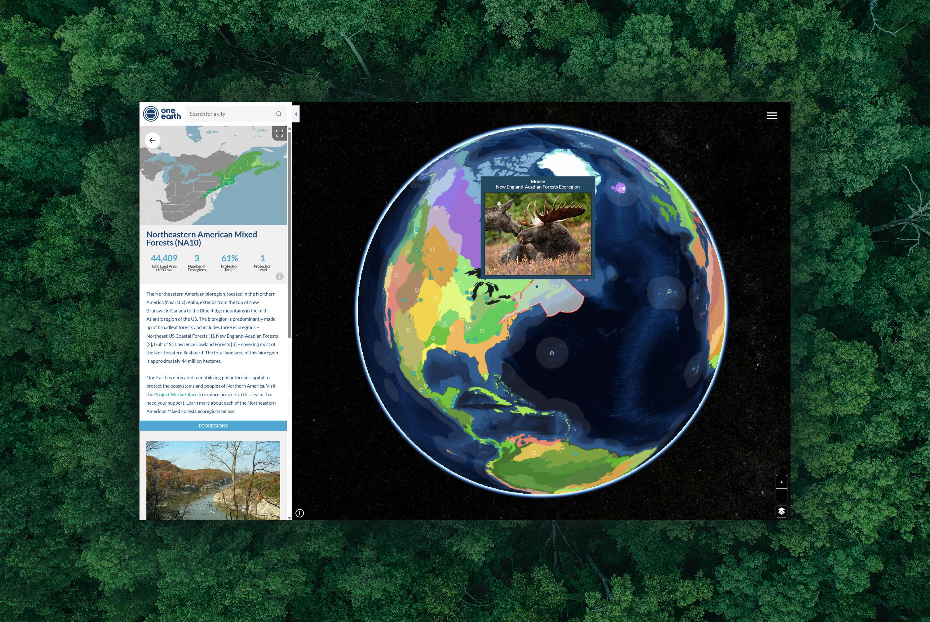
To meet the challenge, Ronik led the creative and technical strategy and full implementation of the Global Navigator platform on OneEarth.org. Built to bridge scientific research and real-world action, the GIS-driven platform features a custom-built 3D globe powered by CesiumJS, integrated within a highly performant Vue-based front end. Users can explore 185 bioregions through intuitive filters, geo-targeted location features, and multimedia-rich storytelling that brings conservation science to life.
A custom geospatial data visualization system powers the experience, combining interactive mapping with ecological datasets to create a seamless and scalable interface. The 3D globe was built using CesiumJS, a powerful open-source framework customized to support One Earth’s unique bioregional taxonomy and storytelling needs.
To manage data and content, we implemented a GraphQL-powered CMS architecture, allowing One Earth’s team to independently publish updates and scale content. The platform also uses GeoJS to deliver a geo-targeted entry point based on the user’s location—connecting local action to a global vision. We avoided costly proprietary systems like Mapbox, instead crafting a custom, ownable solution optimized for performance and extensibility.

We collaborated closely with One Earth’s leadership and in-house experts to define the platform’s purpose, user pathways, and data priorities. Our discovery process focused on understanding the distinct goals of conservation scientists, philanthropic funders, and environmental advocates—and translating those into actionable UX and content strategies. This included detailed wireframes, content modeling, and the accurate translation of One Earth’s newly defined bioregional map—the most up-to-date, scientifically validated framework of its kind. Working with One Earth’s research team, we converted complex vector data into code-defined map shapes and dynamically linked them to conservation projects, creating a first-of-its-kind digital representation of global bioregions.
Since launch, the Global Navigator has significantly expanded visibility for bioregional conservation efforts—leading to $2.4 million in grants for over 70 Marketplace projects. The platform earned a 2024 Webby Anthem Award (Silver) for its innovation and impact, solidifying One Earth’s role as a leader in using digital tools to scale climate action and connect scientific vision with fundable, on-the-ground solutions.
This project is one chapter in a long-term collaboration that continues to evolve, with Ronik providing ongoing strategic and technical support for One Earth’s growing network of innovative, mission-driven initiatives.

iCivics
Digital platform design for a vision-driven EdTech brand